 Scale: 1:800,000
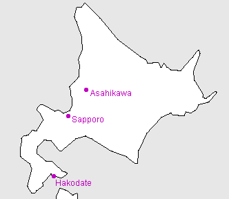
This map covers Hokkaido, the northernmost island of Japan, and also Kunashiri and the other disputed islands to the east of Hokkaido which are under the de facto control of Russia.
Hokkaido is the second largest island and largest prefecture: capital Sapporo
Kanji key
 | Hokkaido |
 | Asahikawa |
 | Sapporo |
 | Hakodate |
Useful generic kanji
 | ken ("prefecture") |  | yama or -san (mountain or Mt.-) |
 | shi ("city") |  | kawa or gawa (river) |
 | machi or cho ("town") |  | shima or tou (island) |
 | mura or son ("village") |  | mizu-umi or -ko (lake) |
General map symbols
 | Expressway; access points with names ("IC" for 'interchange' in Japanese) |
 | Other toll roads |
 | National roads; route numbers |
 | Other roads |
 | Shinkansen ("bullet train") |
 | Other railways |
 | Ferry routes |
 | Prefectural (ken) boundaries |
 | Minor boundaries (cities, etc.) |
| Prefectural capital |
| City offices |
| Minor offices (towns, etc.) |
| Buddhist temple |
| Shinto shrine |
| Castle ruins |
| Famous sites |
| Lighthouse |
| Onsen (hot springs) |
| Waterfall |
| Airport |
| Port |
| Skiing |
| Maple viewing |