 Scale: 1:720,000
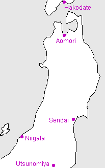
The Tohoku (literally "East-North") region covers the northern part of Honshu.
Kanji key
 | Tohoku |
 | Hakodate |
 | Aomori |
 | Sendai |
 | Niigata |
 | Utsunomiya |
Useful generic kanji
 | ken ("prefecture") |  | yama or -san (mountain or Mt.-) |
 | shi ("city") |  | kawa or gawa (river) |
 | machi or cho ("town") |  | shima or tou (island) |
 | mura or son ("village") |  | mizu-umi or -ko (lake) |
General map symbols
 | Expressway; access points with names ("IC" for 'interchange' in Japanese) |
 | Other toll roads |
 | National roads; route numbers |
 | Other roads |
 | Shinkansen ("bullet train") |
 | Other railways |
 | Ferry routes |
 | Prefectural (ken) boundaries |
 | Minor boundaries (cities, etc.) |
| Prefectural capital |
| City offices |
| Minor offices (towns, etc.) |
| Buddhist temple |
| Shinto shrine |
| Castle ruins |
| Famous sites |
| Lighthouse |
| Onsen (hot springs) |
| Waterfall |
| Airport |
| Port |
| Skiing |
| Maple viewing |