 Scale: 1:550,000
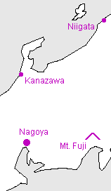
Chubu ("Central region") is the rather indeterminate area between the west (Kansai) and east (Kanto), including the big city of Nagoya. The region doesn't seem to be very clearly defined: often the northern part (on the Sea of Japan) is called Hokuriku.
Kanji key
 | Chubu - the "Central" region |
 | Niigata |
 | Kanazawa |
 | Mt. Fuji |
 | Nagoya |
Useful generic kanji
 | ken ("prefecture") |  | yama or -san (mountain or Mt.-) |
 | shi ("city") |  | kawa or gawa (river) |
 | machi or cho ("town") |  | shima or tou (island) |
 | mura or son ("village") |  | mizu-umi or -ko (lake) |
General map symbols
 | Expressway; access points with names ("IC" for 'interchange' in Japanese) |
 | Other toll roads |
 | National roads; route numbers |
 | Other roads |
 | Shinkansen ("bullet train") |
 | Other railways |
 | Ferry routes |
 | Prefectural (ken) boundaries |
 | Minor boundaries (cities, etc.) |
| Prefectural capital |
| City offices |
| Minor offices (towns, etc.) |
| Buddhist temple |
| Shinto shrine |
| Castle ruins |
| Famous sites |
| Lighthouse |
| Onsen (hot springs) |
| Waterfall |
| Airport |
| Port |
| Skiing |
| Maple viewing |