 Scale: 1:450,000
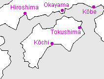
Shikoku is the smallest of the four large islands of Japan; the name ("four countries") refers to the fact that it formerly comprised four of the old kuni, corresponding to the modern prefectures of Kagawa, Kochi, Ehime, and Tokushima.
Kanji key
 | Shikoku |
 | Kobe |
 | Okayama |
 | Hiroshima |
 | Tokushima |
 | Kochi |
Useful generic kanji
 | ken ("prefecture") |  | yama or -san (mountain or Mt.-) |
 | shi ("city") |  | kawa or gawa (river) |
 | machi or cho ("town") |  | shima or tou (island) |
 | mura or son ("village") |  | mizu-umi or -ko (lake) |
General map symbols
 | Expressway; access points with names ("IC" for 'interchange' in Japanese) |
 | Other toll roads |
 | National roads; route numbers |
 | Other roads |
 | Shinkansen ("bullet train") |
 | Other railways |
 | Ferry routes |
 | Prefectural (ken) boundaries |
 | Minor boundaries (cities, etc.) |
| Prefectural capital |
| City offices |
| Minor offices (towns, etc.) |
| Buddhist temple |
| Shinto shrine |
| Castle ruins |
| Famous sites |
| Lighthouse |
| Onsen (hot springs) |
| Waterfall |
| Airport |
| Port |
| Skiing |
| Maple viewing |